


Contact Info
Northern Virginia Regional Park Authority
Ball's Bluff Road
Leesburg, VA 20176
Ball's Bluff Road
Leesburg, VA 20176
- Phone:
- 703-737-7800
Basic Directions
From the Capital Beltway (I-495), take Route 7 west toward Leesburg, then Route 15 Bypass north. Turn right on Battlefield Parkway and left on Ball's Bluff Road. The park is located at the end of the street.
Description
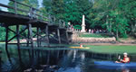
The 223-acre park surrounds one of the smallest national cemeteries, where 54 Union soldiers are buried. The Potomac shoreline park also includes an 1861 Civil War battlefield and hiking trails.

