


Basics
- Length:
- 14.3 miles (23 km)
- Time:
- Allow 20 minutes to drive the byway; more to enjoy the recreational and wildlife viewing opportunities along the way.
- Fees:
- No fees.
Description
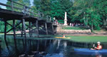
WV Route 72 provides beautiful views of the Cheat River Canyon.The river remains close to its primitive state for nearly six milesalong the route, and with the exception of the town of Rowlesburg,there is little development along the byway. In fact, certainsections of the road give travelers the sensation of completeisolation. Numerous pulloffs provide views of the rugged rivercanyon, Buckhorn Run Waterfall and the Tray Run Viaduct. The regionis also known for the rail and industrial sites that supportmineral extraction and the railroads that served them. With thegrowth of the whitewater rafting industry, the region is becomingequally well-known for its recreational opportunities.
Tourism Resources
Helpful Links
Tourism Resources
Details
Length:
14.3 miles (23 km)
Time:
Allow 20 minutes to drive the byway; more to enjoy the recreational and wildlife viewing opportunities along the way.
Fees:
No fees.

